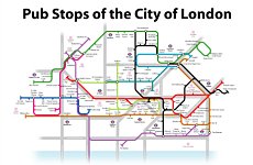
EVER WANDERED around the streets of the City of London looking for that oft-recommended, yet well concealed drinking den gem?
Popular on LondonNet
Well, with his fresh take on the underground map, maths teacher John Coats might just be able to help.
The ‘Pub Stops of the City of London’ poster contains 124 pubs within the square mile indicated as ‘stops’ on a tube map. The main roads, key landmarks (and of course the real underground stations) are also featured.
This is the latest offering from his firm JJM Designs who have produced similar Pub Stops designs for other cities and regions of the country, and even have a ‘Tube Map of the World’ design.
“The London design was a must for us with the obvious underground connection, but we didn’t want to go ahead with this until we’d got the all clear from Transport for London,” said John.
John juggles his map-making hobby with his job as a maths teacher in a Sheffield secondary school.
Make ours a half then, John.
The new Pub Stops of the City of London poster is on sale from Friday 27th August and will initially be available at www.pubstops.co.uk and from Stanfords map shop in Covent Garden.


